author Angelo Gladding
name Fire
published 2025-05-19T18:15:55.371143-07:00
type entry
updated 2025-12-30T14:49:02.172014-08:00
url /fire, /2025/05/20/a5
visibility public
Content
1 2 3 4 5 6 7 8 9 10 11 12 13 14 15 16 17 18 19 20 21 22 23 24 25 26 27 28 29 30 31 32 33 34 35 36 37 38 39 40 41 42 43 44 45 46 47 48 49 50 51 52 53 54 55 56 57 58 59 60 61 62 63 64 65 66 67 68 69 70 71 72 73 74 75 76 77 78 79 80 81 82 83 84 85 86 87 88 89 90 91 92 93 94 95 96 97 98 99 100 101 102 103 104 105 106 107 108 109 110 111 112 113 114 115 116 117 118 119 120 121 122 123 124 125 126 127 128 129 130 131 132 133 134 135 136 137 138 139 140 141 142 |  <div id="map" style="width: 100%; height: 70vh"></div> <link href="https://api.mapbox.com/mapbox-gl-js/v2.15.0/mapbox-gl.css" rel="stylesheet" /> <script src="https://api.mapbox.com/mapbox-gl-js/v2.15.0/mapbox-gl.js"></script> <script> mapboxgl.accessToken = 'pk.eyJ1IjoicmFndC1hZyIsImEiOiJjbWR3ZjZ5cjkxMmRhMmtwbHVlcDBrN240In0.nCEdq0_XYbjl8jq6YV4p5g' const map = new mapboxgl.Map({ container: 'map', style: 'mapbox://styles/mapbox/satellite-streets-v12', center: [-118.1573, 34.1103], zoom: 13 }) map.on('load', async () => { // NOTE: use the new file that excludes NonWildland const fhsz = await ( await fetch('/media/ervG.geojson') ).json() map.addSource('sp-fhsz', { type: 'geojson', data: fhsz }) map.addLayer({ id: 'sp-fhsz-fill', type: 'fill', source: 'sp-fhsz', paint: { 'fill-color': [ 'match', ['get', 'FHSZ_Descr'], 'Very High', '#dc322f', // red 'High', '#cb4b16', // orange 'Moderate', '#b58900', // yellow /* fallback */ '#b58900' ], 'fill-opacity': 0.45 } }) map.addLayer({ id: 'sp-fhsz-outline', type: 'line', source: 'sp-fhsz', paint: { 'line-color': '#002b36', 'line-width': 2 } }) map.on('click', 'sp-fhsz-fill', e => { const p = e.features[0].properties new mapboxgl.Popup() .setLngLat(e.lngLat) .setHTML( `<strong>$${p.FHSZ_Descr}</strong><br>` + `Code: $${p.FHSZ}` ) .addTo(map) }) map.on('mouseenter', 'sp-fhsz-fill', () => (map.getCanvas().style.cursor = 'pointer')) map.on('mouseleave', 'sp-fhsz-fill', () => (map.getCanvas().style.cursor = '')) // Optional: auto-fit to all displayed zones // (You can delete if you prefer fixed view) const b = new mapboxgl.LngLatBounds() for (const ft of fhsz.features) { const coords = ft.geometry.type === 'Polygon' ? ft.geometry.coordinates.flat(1) : ft.geometry.coordinates.flat(2) for (const c of coords) b.extend(c) } map.fitBounds(b, { padding: 24 }) }) </script> ## Fire Hazard Severity Zones (FHSZ) [November 2022](/media/F3mV.pdf), [June 2023](/media/WojZ.pdf), [September 2023](/media/14Qo.pdf) ## March 2025 ### Fire Hazard Severity Zone Viewer https://experience.arcgis.com/experience/6a9cb66bb1824cd98756812af41292a0 This viewer allows you to zoom in to see individual addresses.
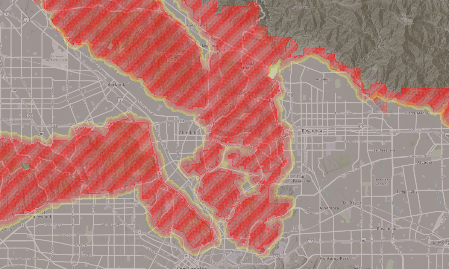
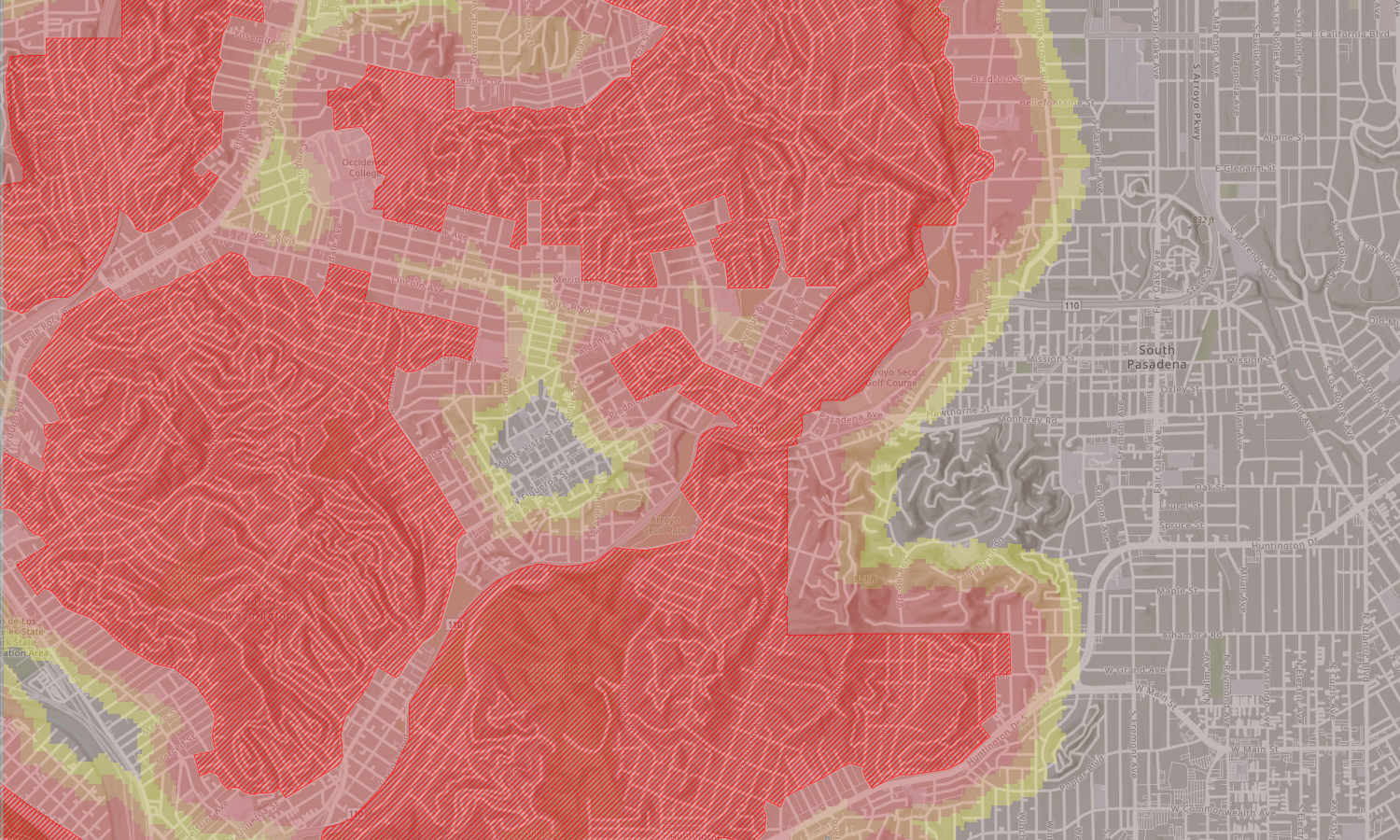
  ### Changes Cross-thatched red was preexisting. Solid red/orange/yellow represents expanded scope as of March 2025.
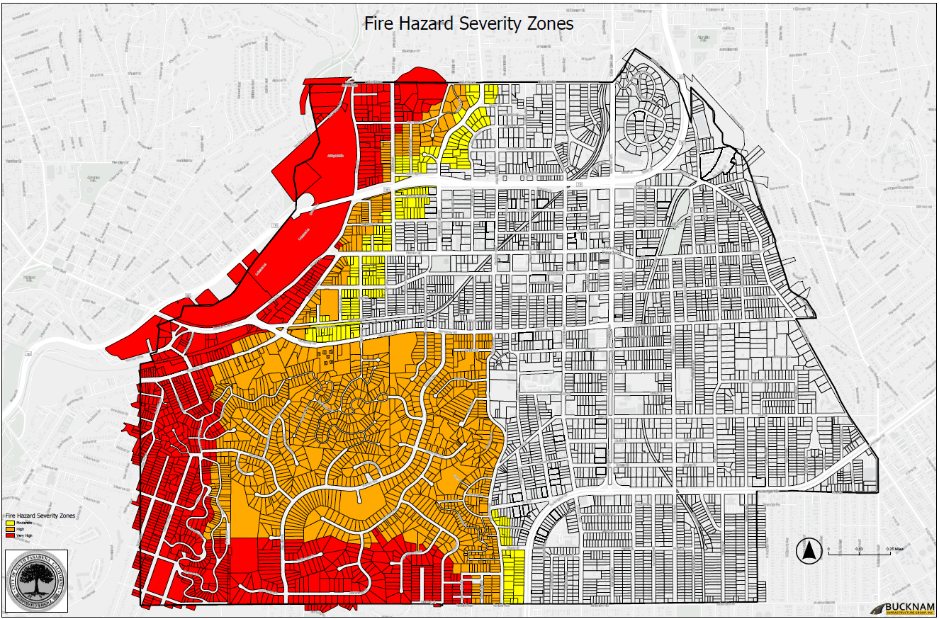
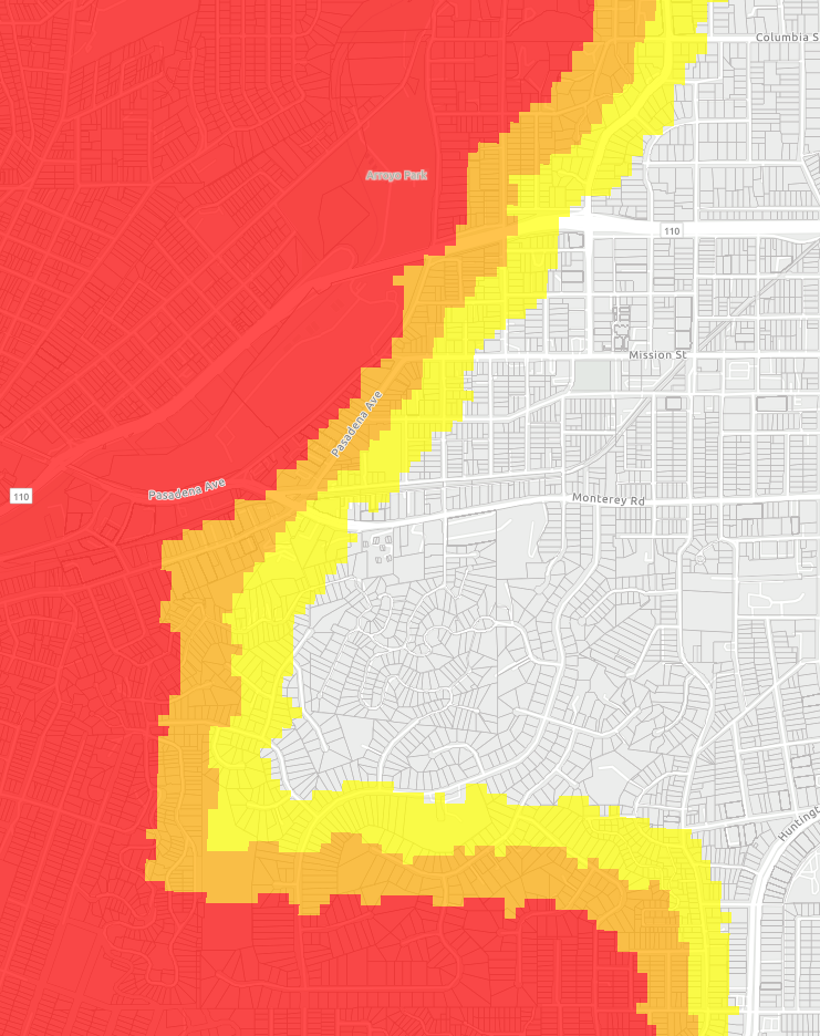
 ### Full South Pasadena interface  <!--map name=fullinterface> <area shape=rect coords="34,44,270,350" href=/media/m3UM.png alt="Upper Arroyo"> </map> <table> <tr> <td> <tr> <td> <tr> <td> <tr> <td> <tr> <td> <tr> <td> <tr> <td>   </td> </table--> ### 
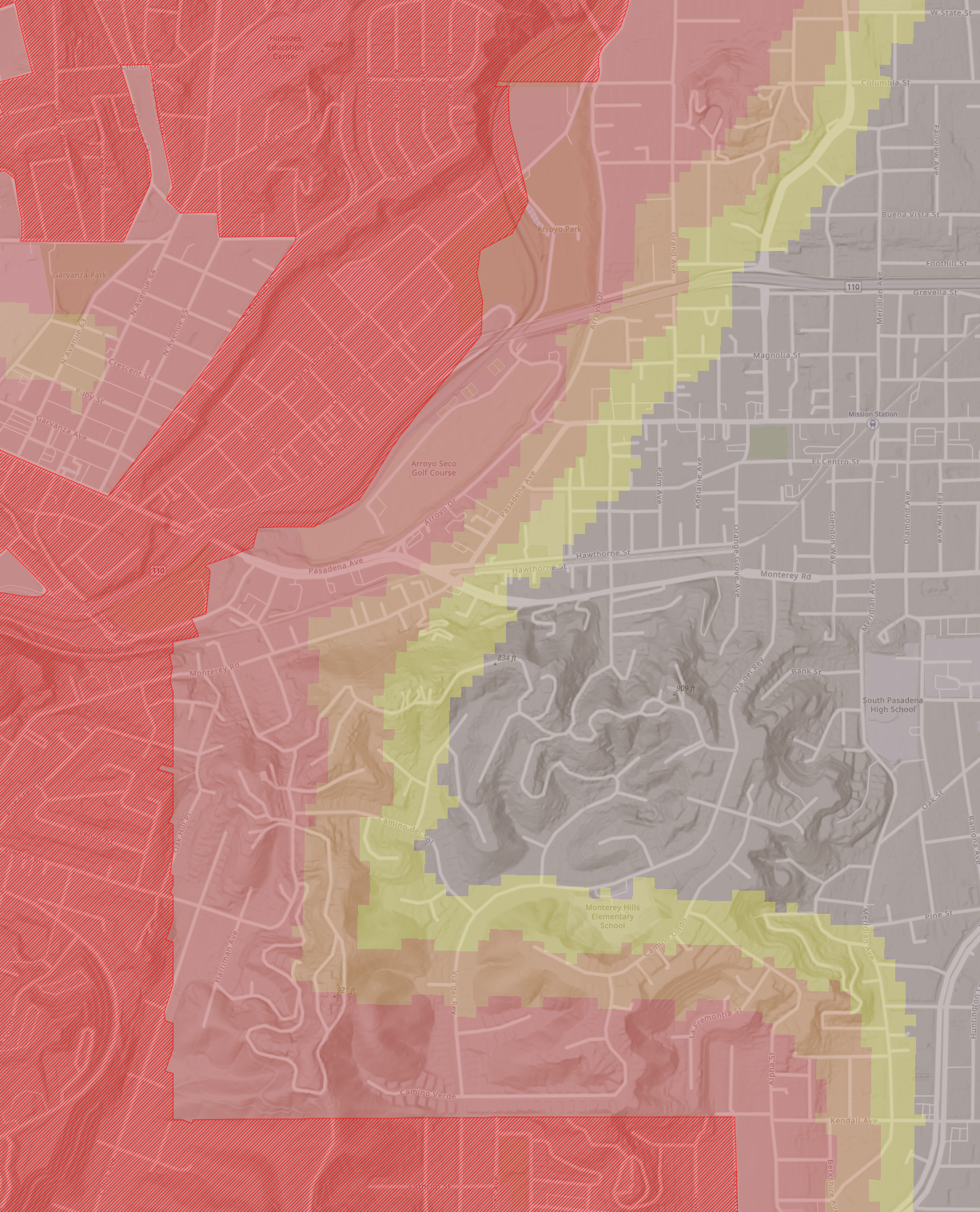
Monterey Hills, South Pasadena  ### Cities Surrounding South Pasadena  ### Hahamongna Watershed, Santa Monica Mountains, Verdugo Mountains & San Gabriel Mountain Foothills  |